- Policy Analysis
- PolicyWatch 4228
Tracking the Islamic State: Activity Trends, African Shifts, and U.S. Dormancy
Jun 11, 2026
Also available in
About the Authors

Brief Analysis
As a landmark tool for monitoring the group’s activity hits another sobering milestone, U.S. officials cannot let regional crises completely overshadow important shifts in jihadist threats around the world.
In March 2023, The Washington Institute launched the Islamic State Select Worldwide Activity Map in order to track the organization more holistically than attack data alone allowed, incorporating propaganda activity, claims of responsibility, financial sanctions, and legal cases. Three years and 5,000 database entries later, the picture provided by this interactive map has changed in ways that both confirm and complicate the trends identified at its one-year mark. The core IS “provinces” in Iraq and Syria are not just degraded—they have largely fallen off the operational map. In their place, an almost entirely African set of “provinces” now carries the IS torch of global jihadist insurgency and terrorism. And even as the group’s attacks grow deadlier per incident, the U.S. government’s tools for confronting IS financial and recruitment networks sit largely unused.
Growing Lethality, Shift to Africa
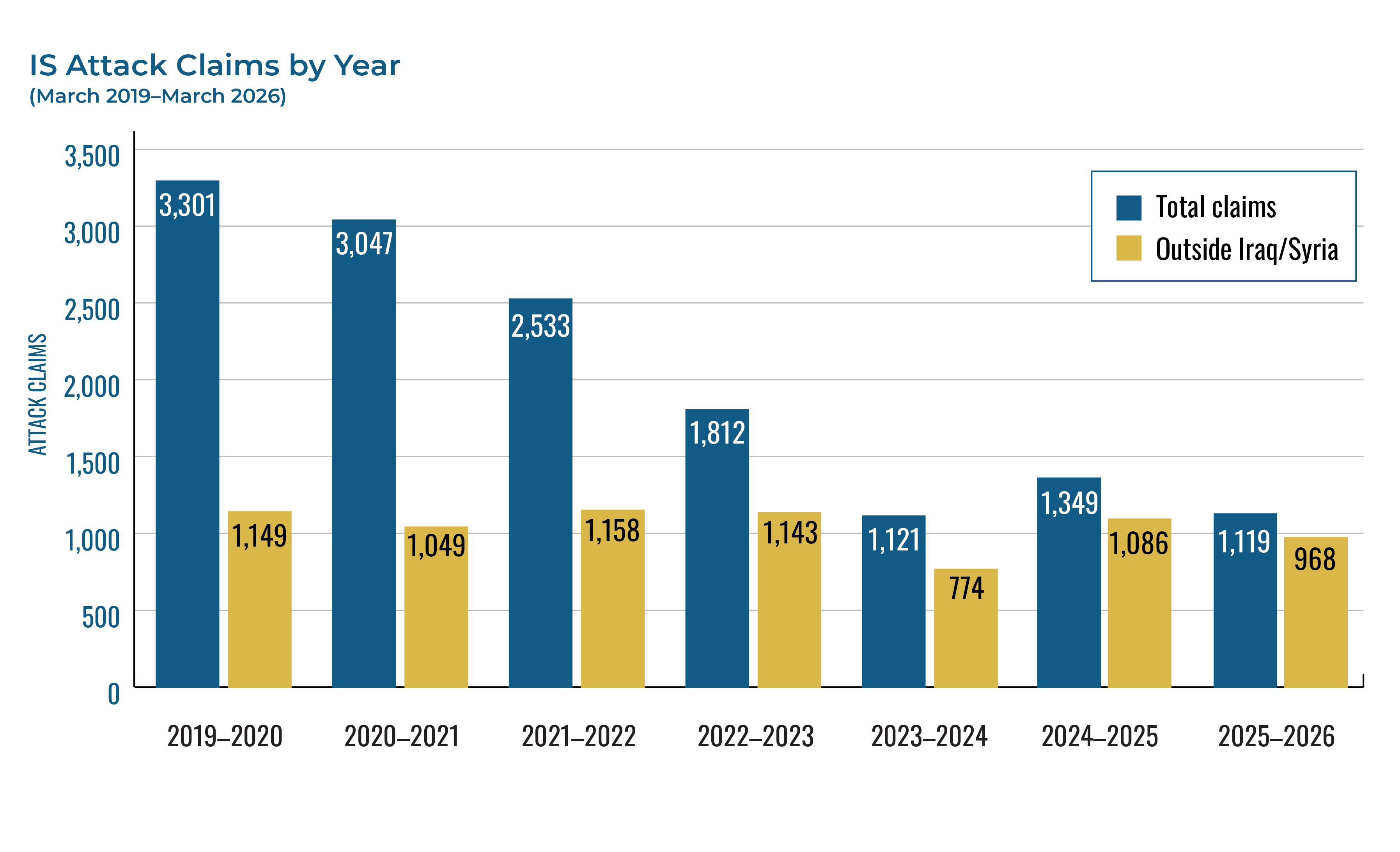
When the map was launched, it began by retroactively cataloging IS activity since 2019, then commenced recording new activity as it happened, enabling researchers to assess annual trends. According to this data, the IS central media administration claimed more than 3,500 attacks between 2019 and 2026, resulting in more than 15,000 reported casualties. Although the annual tempo of these attacks remained roughly the same, their lethality has been steadily increasing: the number of casualties has climbed from roughly 4.1 per attack to 4.6. The fact that attacks over the past year were, on average, the deadliest recorded by the map is a reminder that a plateau in frequency is not the same as a reduction in threat.

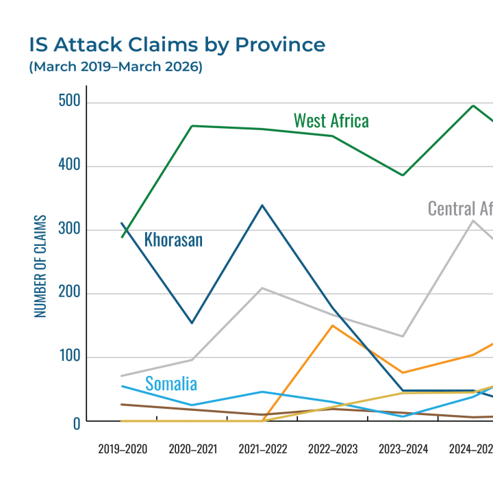
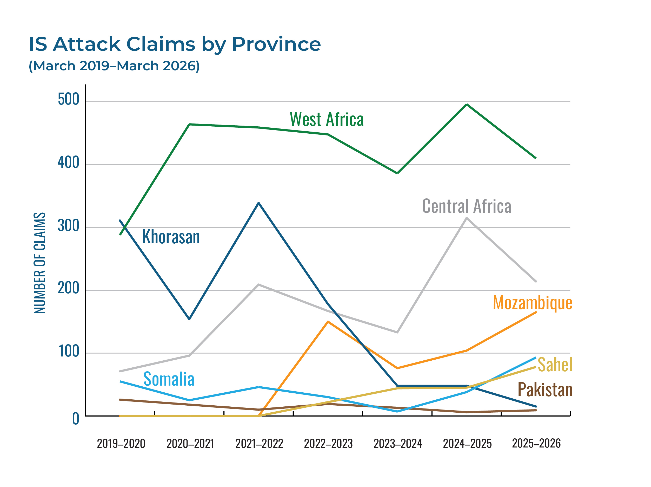
Meanwhile, the provincial hierarchy described at the map’s one-year mark has been redrawn. The Islamic State’s West Africa “province” (ISWAP) has become the single most active, though its claims have eased from their second-year peak. The most dramatic movement came from the group’s other African fronts. The Central Africa province, based in the Democratic Republic of Congo, more than doubled its claims in year two of the map, and the Sahel province in Mali continued its climb as well. The Mozambique province was temporarily deterred by leadership attrition but then returned to a sustained offensive and surged to its highest number of attack claims in year three. Most striking of all, the Somalia province rose from 7 claimed attacks in the first year of the map to 93 in the third—a thirteenfold increase that mirrors the sub-group’s growing prominence within the IS network.

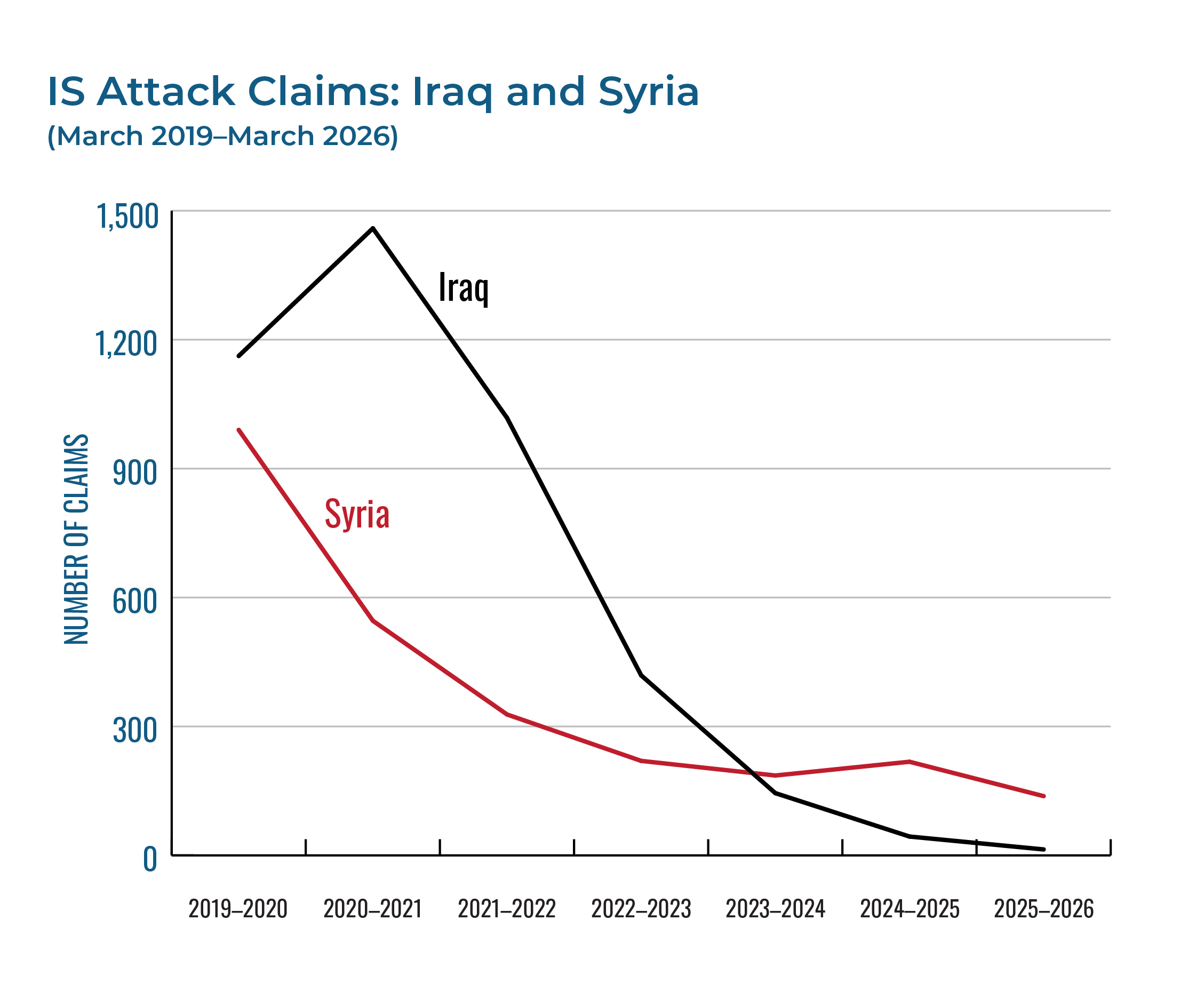
Against this African ascent, the organization’s birthplace has gone relatively quiet. Claimed attacks in Iraq collapsed from 145 in the first year to 14 in the third—the product of sustained counterterrorism pressure. Claims in Syria declined as well, consistent with the group’s deliberate policy of underreporting there, and also with the upheaval that followed the Assad regime’s ouster in 2024. Similarly, attack claims by the Khorasan province (ISKP) fell sharply inside Afghanistan, reflecting an escalation in Taliban military measures against the group. Yet ISKP expanded the part of its operations that matters most to U.S. policy: external plotting.

Halt in U.S. Designations
During the first year of the map’s existence, the U.S. government issued four designations sanctioning twenty-four individuals. At the time, Washington’s growing focus on Russia, China, and Iran was already pulling attention away from designating IS networks, and that drift has since become a complete halt. After a final tranche was issued on July 23, 2024, the map recorded no further U.S. designations.
This dormancy is difficult to reconcile with developments on the ground. Over the same period, the Islamic State’s African provinces have expanded both their territorial reach and their capacity to extract resources that can be used to fund terrorism—precisely the conditions that warrant identifying and sanctioning the financiers, facilitators, and leaders who sustain them. Designations have long been a useful way to not only constrain illicit activity, but also bring shadowy new figures into public view. By allowing this tool to lapse while the IS threat diversifies, Washington is forfeiting both benefits.
Arrest Patterns
The volume of IS-related legal cases tracked by the map has remained large: roughly 480 cases in the first year, rising to 549 in the second before easing to 408 in the third. This caseload spans more than ninety countries in total, and its composition has shifted in two consequential ways.
First, the geographic center of gravity moved. Turkey, Iraq, and northeast Syria led the early figures. By year three, Syria stood firmly atop the list, reflecting the wave of detentions and prosecutions that accompanied the post-Assad transition and the continued precariousness of the detainee population in the northeast.
Second, and more troubling, the Western caseload has skewed younger and more online. Cases involving minors peaked in year two, largely clustering in France, the United States, Germany, Austria, and Canada. These cases are almost always tied to online radicalization, social media activity, and plots against domestic targets rather than foreign fighting. Artificial intelligence usage is a nascent but important trend—the map has tracked six cases involving AI, primarily used by adolescents to gain know-how on producing explosives. As AI develops in the coming years, it will likely serve as both a force multiplier and a security vulnerability, with terrorist users exploiting ever more sophisticated AI platforms.
Propaganda Activity
The map’s data reveals a divergence between the Islamic State’s two flagship periodicals, mirroring the organization’s broader trajectory. Its Arabic-language weekly newsletter, al-Naba, remained consistent. Yet Voice of Khurasan—ISKP’s English-language magazine aimed at a global and diaspora readership—followed a different path. It ran more or less consistently through the first two years of the map before collapsing in the third, dwindling to a handful of issues as the publication fell largely silent in the latter half of 2025. The dismantling of an ISKP media network by Pakistani police last August helps explain that decline.
The two publications serve distinct functions, and the contrast is instructive. Al-Naba operates as a bulletin for news and doctrine, documenting the group’s battlefield operations and governance activities (overwhelmingly in Africa). Its content has increasingly fixated on the United States and the Trump administration, while also sustaining heavy anti-Jewish messaging and sectarian denunciation of rival Muslims—including the Taliban, Hamas, and Hayat Tahrir al-Sham, the now-defunct group formerly led by Syrian President Ahmed al-Shara.
Voice of Khurasan reads more as a teaching and recruitment magazine. Its most frequent content comprises devotional histories of the Prophet Muhammad’s companions, Quranic narratives, calls to mobilization and emigration, denunciations of the Taliban and Pakistan, a dedicated strand addressing female readers, and appeals to local Muslim minorities, from the Uyghurs to Kashmir.
The clearest common ground between the two publications is their hostility toward Israel and Jews. This theme intensified across both publications after the October 7 Hamas attack on Israel.
Year Four So Far
The opening weeks of the map’s fourth year of tracking the Islamic State suggest continuity rather than rupture. The pace of claimed attacks points toward another year in the familiar band of roughly 1,100-1,300 incidents—neither the breakout some feared due to deteriorating security in Africa nor the collapse others hoped for. ISWAP is still dominating, while the Central Africa, Mozambique, and Sahel provinces hold steady, and Iraq and Syria continue to fade.
Two early signals merit attention as year four unfolds: the Somalia province’s claims appear to be cooling from their third-year surge, but ISKP’s claims of attacks inside Afghanistan show tentative signs of rebounding. Should these patterns hold over the coming months, the fourth year of the map would consolidate the central finding of the first three: that the Islamic State is now, first and foremost, an African insurgency with a dangerous transnational plotting capability anchored in Afghanistan. This African pivot has pushed the group away from the center of the Islamic world, potentially challenging its claims of religious legitimacy. Yet it might also make IS more dangerous from a U.S. policy perspective, since the group is now concentrated in a region where Russian mercenaries dominate the counterterrorism picture, American operational capacity lags, and the machinery of U.S. government designations is still inert.
Policy Implications
The years of data compiled by the Islamic State activity map highlight the need for continued U.S. policy engagement on this issue, with a focus on the following trends:
- The consolidation of the group’s African “provinces” is no longer a trend to anticipate, but a reality to confront. So far, however, the U.S. government has seemingly abandoned the most appropriate response mechanism: renewing and expanding designations of IS financial and leadership networks. This trend was also evident in the Trump administration’s recently released counterterrorism strategy document—a gap that officials should work to close as much as possible.
- The youthful, online tilt of recent arrest data argues for sustained investment in prevention and off-ramp programs that address radicalization before it reaches the plotting stage, particularly in Western Europe and North America. Increased collaboration between the public and private sector is key to this endeavor, since social media and AI companies sit at the tip of the IS radicalization spear.
- ISKP’s persistent ambition to plan and conduct external operations has exposed the hollowness of the Taliban’s counterterrorism assurances, illustrating the continued need for global intelligence and information sharing to prevent any future mass atrocity attacks.
- Above all, the fall of the Assad regime has transformed the Islamic State’s original epicenter in a way that previous analysis could only war-game. The large detainee population in the northeast has mostly been moved to Iraq, the strain on the Syrian Democratic Forces is now being shared through an integration agreement with the central government, and the contest for territory in that part of Syria was resolved in late January. IS has every incentive to exploit the country’s ongoing instability and uncertainty—indeed, its propaganda outlets have eagerly seized on the situation, as monitored by the map since late 2024. Yet all indications suggest that Damascus is now up to the task and can serve as a key member of the Global Coalition against IS.
Amid continued calls to wind down the counter-IS coalition, the lesson of the map’s first three-plus years in operation is that IS adapts faster than the attention paid to it. The Islamic State Worldwide Activity Map will continue to track that adaptation wherever it migrates next.
Aaron Y. Zelin is the Gloria and Ken Levy Senior Fellow at The Washington Institute, director of its Islamic State Worldwide Activity Map project, and founder of the acclaimed website Jihadology.net.
Share